Search results
-

222 archery elk hunt
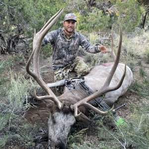
Sadly I didn’t see the suggestion to hunt low until after I came back to share my bull. But I did find him down low. Thank you!- velvetaddict
- Post #58
- Forum: Nevada
-
222 archery elk hunt
I believe he’s a piebald, his whole body was kinda that color, I don’t think he’s super old. But not sure- velvetaddict
- Post #53
- Forum: Nevada
-
-
222 archery elk hunt
I believe he’s piebald, I found him dead 30 minutes after I shot him- velvetaddict
- Post #41
- Forum: Nevada
-
222 archery elk hunt
- velvetaddict
- Post #38
- Forum: Nevada
-
ECD5CFE1-6709-4274-9763-2EF437FC356E.jpeg
- velvetaddict
- Media item
- Comments: 0
- Category: Photos Shared in State Forums
-
222 archery elk hunt
I ended up drawing the tag and harvested this diy bull yesterday- velvetaddict
- Post #37
- Forum: Nevada
-
222 archery elk hunt
lol, you do realize no one is able to frequently hunt this area right? Giving insight on general areas you found animals at will in no way affect the way you hunt in the minimum 20 year span it will take you to pull that tag again, if you ever do pull it again. Makes no sense but different...- velvetaddict
- Post #24
- Forum: Nevada
-
222 archery elk hunt
Yeah that’s why I want to learn about the areas I’m thinking about putting in for. Cause it’ll be awhile till I’ll get another- velvetaddict
- Post #20
- Forum: Nevada
-
222 archery elk hunt
I was thinking the same thing, I’d rather do it on my own and fail than pay a dude to do it for me- velvetaddict
- Post #19
- Forum: Nevada
-
222 archery elk hunt
I was also thinking about this too, it’s still not a great chance for me to get a tag this year, but since I’m getting up there in points I want to be certain of the areas I’m putting in for. Since after you get a tag it’s still a minimum of 12-15 years till you’ll pull another. And if I don’t I...- velvetaddict
- Post #16
- Forum: Nevada
-
222 archery elk hunt
I looked at the hunter data sheet or whatever it’s called, and the first 4 or 5 spots it listed were all north of the wilderness area in an area that was between 7,500-9,500ft with a ton of roads. Which I wasn’t too fond of. And on google earth and using GOHUNT, it really didn’t look super steep...- velvetaddict
- Post #13
- Forum: Nevada
-
222 archery elk hunt
Luckily I am a resident, so I’ll get a few Nevada elk tags in my lifetime hopefully, as I am still pretty young. I’ve been researching literally anything I can think of about elk. I’ve learned way more about elk than I knew a couple weeks ago. I know it’s probably nothing compared to real...- velvetaddict
- Post #12
- Forum: Nevada
-
222 archery elk hunt
I realize it’s a learning curve, just like literally anything else related to hunting. Just was hoping someone with experience in this area was willing to share some spots to start- velvetaddict
- Post #9
- Forum: Nevada
-
222 archery elk hunt
To be fair, archery hunting anything for the first time is tough. The only way to learn is to get out there and give it a shot. Thanks for the input- velvetaddict
- Post #8
- Forum: Nevada
-
222 archery elk hunt
I just wanna know areas to check out. Im not new to archery hunting big country in warm weather. Have you hunted this area for elk in this season before?- velvetaddict
- Post #7
- Forum: Nevada
-
222 archery elk hunt
Why? Isn’t that unit supposedly one of the highest populated elk units in the state? Or is that incorrect- velvetaddict
- Post #3
- Forum: Nevada
-
222 archery elk hunt
Im doing some planning for the upcoming tag application, Im starting to get a good amount of elk points so im tryng to get picky with my unit choices. Ive never hunted elk before, and was wondering if anyone has any tips for hunting elk in 222, or just any tips for archery elk hunting would be...- velvetaddict
- Thread
- Replies: 64
- Forum: Nevada