Do you use Google Earth?

Founder

Founder Since 1999
Messages
11,473
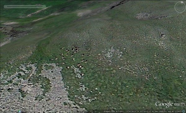
Question of the Day .... Do you use Google Earth? If so, how many times per year do you think you open it up to study an area you will be hunting?
What other map or aerial imagery tools do you use?
Do you think Google Earth has been a serious game changer?


Brian Latturner
MonsterMuleys.com
Will you LIKE MonsterMuleys.com on Facebook! I need a friend....
 
I use it quite frequently. When I am out in the field and see trails or canyons that I don't have time to explore, I make note of them and when I get back to civilization, I spend a fair amount of time studying these places to see how close they are to public access points or private land or??? Definitely a very useful tool! Once summer hits, I explore these new areas to see if they are something worth investing more time in during the hunting season.
 
I use Google Earth along w CPW's free Big Game Atlas, which has public property boundaries, USFS road/trail status, GMU boundaries and info Re summer, winter and migration ranges of deer and elk.
 
I use Alltrails through Nat Geo...I like the way I can print/save customized maps (aerial, topo, 3D etc). Yes, but no substitute for boots on the ground...there have been many areas that looked good w/ the aerials but were impassable on the ground.
 
I do use it,but not as much I once did much since I have Huntmaps.
I use Flashearth for most sat. views.
I still like paper maps best.
 
I love Google earth. It has saved me a lot of time and energy. I plan out full days using it, including distances. Sometimes it is hard to scout as much as I would like, but Google earth makes a great supplement. Notice I said "supplement" for scouting, not replacement. I don't have time to hike to everywhere I am curious about...google earth helps with this.

For me, it was and is a game-changer.
 
I use it all the time. In fact, I was just looking at it with a buddy this morning. It is a great tool.

Hawkeye

Browning A-Bolt 300 Win Mag
Bowtech Destroyer
Winchester Apex .50 Cal
 
I use it a ton for exploring new areas. Find routes into remote areas, water sources and cover.


"You can fly a helicopter to the top of Everest and say you've been there. The problem with that is you were an a$$hole when you started and you're still an a$$hole when you get back.
Its the climb that makes you a different person". - Yvon Chouinard
 
I use it all the time. And it's really deceptive. Looks so easy on a computer screen and is so tough in real life. lol
 
I find it useful, especially if I'm looking at a new area.

Moose

Every hunting season you miss is one you can not make up
 
Yes, and did you realize they now offer Google earth Pro for free?

txhunter58

venor, ergo sum (I hunt, therefore I am)
 
All the time.
2625elk_high.jpg
 
>Yes, and did you realize they
>now offer Google earth Pro
>for free?
>
>txhunter58
>
>venor, ergo sum (I hunt, therefore
>I am)


Details tx?
 
A lot

"I have found if you go the extra mile it's Never crowded".
>[Font][Font color = "green"]Life member of
>the MM green signature club.[font/]
 
I quit using it years ago because of it's limitations.
Earth Pro is now available free and many of those limits are gone with the pro version.
 
>I use Alltrails through Nat Geo...I
>like the way I can
>print/save customized maps (aerial,
>topo, 3D etc). Yes,
>but no substitute for boots
>on the ground...there have been
>many areas that looked good
>w/ the aerials but were
>impassable on the ground.


Is Alltrails free?
 
Some, but mostly Terrain Navigator Pro I had it for years and just stayed with it. With google can you do custom maps?
 

Click-a-Pic ... Details & Bigger Photos
Back
Top Bottom