You are using an out of date browser. It may not display this or other websites correctly.
You should upgrade or use an alternative browser.
You should upgrade or use an alternative browser.
12 a-w late
- Thread starter jvgunner
- Start date
H
hawkin
Guest
A friend of mine drew with 1 point.
M
MLog
Guest
I drew as a non-res. I had Max points which I believe was 10 or 11 with the loyalty and hunter ed.
Mike-TN
Mike-TN
K
KaibabHntr
Guest
>who drew & how many points
>did it take. thanks
Not this year, but going in w/6 resident points for 2009...
KaibabHntr
www.KeyToTheKaibab.com
Everything you need to hunt AZ unit 12A!
>did it take. thanks
Not this year, but going in w/6 resident points for 2009...
KaibabHntr
www.KeyToTheKaibab.com
Everything you need to hunt AZ unit 12A!
Bruinbrewin
Active Member
- Messages
- 336
I finally drew with max points and been waiting for approx 15 years. I am hoping to get a nice buck but have never been up in that area. If anyone has any help they could offer I would sure appreciate it. I can't afford the guide route so it is a DIY for me. I hear I should have no problem filling my tag but I would like a nice trophy since it is really a once in a lifetime opportunity. Thanks in advance for any help that is offered. And good luck to anyone that has been lucky enough to draw
BB
>who drew & how many points
>did it take. thanks
BB
>who drew & how many points
>did it take. thanks
B
BOW_N_ARROW
Guest
>who drew & how many points
>did it take. thanks
No tag with 4 resident, but I also but in with a non-res on the same application. Will probably be waiting awhile.
JB
>did it take. thanks
No tag with 4 resident, but I also but in with a non-res on the same application. Will probably be waiting awhile.
JB
B
Bura Nut
Guest
I now have 7 points and will keep trying......everyone who drew, I hope you have a great time, see some monsters and bag the buck of your dreams.......... Thanks, Allen Taylor......
OutdoorWriter
Long Time Member
- Messages
- 8,340
B&A,
Indeed, it might take a while.
Applying with a NR will likely you keep you from ever drawing a late Kaibab hunt unless the BP average for the two of you reaches the max points. Even then, that will be a few years, and there will be many, many more NRs with maz points trying to get the 10% NR permits in the 20% pool.
Also, if by some chance your # comes up in the general draw outside the 20% pool, YOU will not get a permit unless there is also a NR permit availble for your partner. IOW, it's all or none. -TONY
R
RockyMtnOyster
Guest
12AW Late was my first choice for deer, I did not draw, however I drew my second choice for 23 Late coues which is still a tough draw at 5-6%. So if that tells you anything, it's VERY difficult to draw those late kaibab/strip tags.
Good luck to all those who drew!
RockyMtnOyster
Good luck to all those who drew!
RockyMtnOyster
Bruinbrewin
Active Member
- Messages
- 336
12A-W late hunt was my second choice so this must be my year after waiting 15 years to draw.
BB
BB
R
RockyMtnOyster
Guest
Bruinbrewin, Congrats on your tag! If you don't mind me asking, what was your first choice?
RockyMtnOyster
RockyMtnOyster
Bruinbrewin
Active Member
- Messages
- 336
I guess I just thought based on the lower number of tags offered that the 12A-E late hunt was the better of the two hunts. I have been told by a few people that the west hunt is a better hunt even though there is more hunters. I can't wait, all that I've talked to said I should have no problem finding a 180+ buck. If I put in the work hiking I might find something bigger so don't shoot the first 180 that I see.
BB
BB
K
kast1
Guest
180"s are not around every corner dont be fooled, there are lots of deer, you still will need to put in time and scout around ,good luck
jvgunner
Active Member
- Messages
- 159
I drew 12 a-w early in 2003 with 7 nr points, self guided, it was very dry & smoky due to the california wildfires that year, old timers send the worst 1st season in 45yrs, ya my luck, I went home with a small 4x4 gave in 2 days early due to my first child at home, this season was followed by a wet 2nd season one of the best in years (go figure) now I will go into 2209 with 7pts. good luck to ya, check with john @ jacobs lake lodge he should steer you the right way, (eastside game rd) 7 the canyons would be my bet.
K
ktmrider2a
Guest
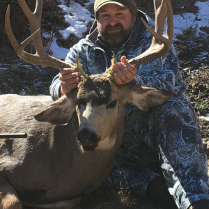
I drew this year as a resident with 10 points (one shy of the 11 max). Tag #30 so I was drawn in the 20% pass group.
I was able to help a friend on this hunt in 04. Lots of fun but as stated above there were not 180" bucks hiding around every corner. He ended up with 160 on the 9th day of hunting. Crossing my fingers and hoping the weather cooperates, can't wait!
I was able to help a friend on this hunt in 04. Lots of fun but as stated above there were not 180" bucks hiding around every corner. He ended up with 160 on the 9th day of hunting. Crossing my fingers and hoping the weather cooperates, can't wait!
A
AZBUGLER
Guest
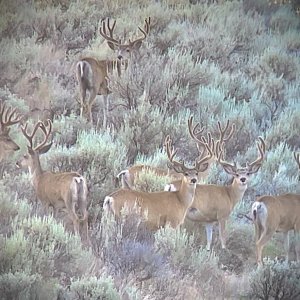
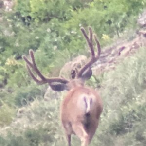
Hunt success depends greatly on the weather. Pray for snow. The more snow the better. If it is dry and warm, it can be a tough hunt. Most years you will have at least some snow and the bucks will be starting to migrate out of the high country.
There are 200 class bucks there for sure, but other are right, they are not around every corner. Your average 4x4 up there averages around 140 BC. If the weather cooperates, and you put in your time, a 160 plus buck really should be fairly easy, a 180 requires a little luck and I would not say "should be no problem". It is , however, a realistic goal if you spend the time there.
The Kaibab Plateau is just that, "a plateau". There are fingers coming off to the West of your unit that come down from 8,000 plus on top to 5,500 in the lower country before it drops off into Kanab Creek. Historic snowy weather areas include Jumpup Point, White pockets, and Pine Hollow. If no snow, the majority of the deer will be on top of the plateau in the thicker cover of Pine/fir/Spruce above these locations. If you get just a dusting and it is cold, the deer will begin their migration, but might hold up in the trasition areas (Burnt Corral, Little Mountain, Bee Springs).Most of these areas are oak, cliffrose, etc.. I have been hunting on the Kaibab for over 20 years. It is gorgeous! Enjoy your hunt!
OutdoorWriter
Long Time Member
- Messages
- 8,340
Here's a snippet from the most recent article I wrote. The main part is about Frank Ferguson's 227" buck, taken in 2007 on the late eastside hunt. -TONY
****
ABOUT THE KAIBAB
The Pah Ute Indians called the North Kaibab Plateau the "mountain lying down."
Bordered on the south by the Grand Canyon and near desert on the other sides, the plateau rises like a tree-covered sky island from a sea of sand and rocks. To the east lies Houserock Valley, and to the west sits the somewhat barren Arizona Strip country.
Elevations on the Kaibab vary from 3,000 feet to more than 9,000 on V.T. Ridge, the highest point. Ponderosa pines, aspen, spruce and fir grow at the higher elevations. Pinion pines, junipers and cedars dominate the lower ridges and canyons, which run off the plateau like the spokes of a wheel. In between, the transitional zones offer plenty of oaks and mixture of all the above.
Since the huge crash of the deer herd in the 1920s and 1930s, the Kaibab has often experienced widely fluctuating deer numbers. Despite the problems, though, the Kaibab has maintained its reputation as Arizona?s big buck factory. The major records books list many typical and non-typical deer from past decades, and almost every year a few more get added.
Old-timers who had hunted there the 1940s and 50s commonly recounted tales of hundreds of deer migrating in single file down from Big Saddle and Sowats Point on the west or into Potato Canyon to the east after a big snowfall. They fondly referred to those times as the REAL glory years of the Kaibab.
The deer stay at the high elevations during the summer and early fall months, but when the snow flies and temperature drops, thus freezing the deer? favorite foods at the higher elevations, they head down to the lower ranges. By late November or early December, most of them have moved into the canyons and brushy pockets formed by the cedar-covered ridges that lead down to the flats.
For more than a decade now, a drought in the West has caused declines to the mule deer populations in several states, including Arizona, but the deer on the North Kaibab Plateau have done comparatively well. One reason has been the heavy snows that have kept the habitat at the higher elevations in decent shape.
One concern of the Arizona Game and Fish Department has been the area in and around the site of the Bridger-Knoll forest fire that occurred several years ago. Consisting of mostly juniper-pinyon vegetation, the area that burned is within the prime wintering grounds for the deer that migrate westward. Even though it's recovering nicely now, the game department has been micro-managing it with various junior hunts for antlerless deer. The purpose is simple: keep the numbers down until the habitat fully recovers.
As part of its Wildlife 2006 strategic plan, the department's top priority is managing the Kaibab deer herd with a main goal of quality. More specifically, the aim is having fewer hunters, higher success rates for the early season and better-than-average chances to kill a wall-hanger buck. An increase in the buck-to-doe ratio toward the objective set by the strategic plan is one of the management keys the agency is using.
In 2007, the combined total for permits for the Oct. and Nov. seasons on the west side was 825. The two seasons for the east side totaled 225 permits. The success rates in 12AEast were 44 percent for the early season and 84 percent for the late hunt. In 12AWest, they were 55 and 72 percent respectively.
Highway 67, which goes from Jacob Lake to the north rim of the Grand Canyon, provides access to many logging roads at the higher elevations. It also passes through the area where the Warm fire burned nearly 40,000 acres of the deer?s summer range in 2006.
On the east side, the road (FS445) from State Highway 89 to the Houserock Ranch area skirts alongside some of the better low-country habitat, and the Eastside Game Trail (FS220) goes northwest from the Houserock Road into prime hunting country. All the ridges in this area can be productive during the late hunt if there's snow high up.
On the west side, the road (FS422) to Big Springs, which originates near Fredonia, is also accessible from Jacob Lake via FS461 and FS462. From there, a literal maze of lesser roads can be found.
OutdoorWriter
Long Time Member
- Messages
- 8,340
I'll seriously consider your suggestion, Don. ;-) -TONY
A
AZbowhntr
Guest
That's funny. After having the early tag a couple years ago and going up with a friend last year I would not pass up a 180" buck for anything. That being said I saw some REAL big bucks taken. And I shot my buck on the early hunt off of jump up point. So them bucks are everywhere. The best advice I can give anyone is call Duwane Adams and at least use his map service. It is worth its weight in gold.
By the way, the friend that I helped on the late hunt last year drew an early tag this year. So did the guy that he hunted with which was the big guy that shot the 240" buck. Talk about luck.
By the way, the friend that I helped on the late hunt last year drew an early tag this year. So did the guy that he hunted with which was the big guy that shot the 240" buck. Talk about luck.
3
338snipetac
Guest
myself 7 points; resident
2 friends of mine 3 points; residents
2 friends of mine 3 points; residents
Similar threads
- Replies
- 1
- Views
- 477