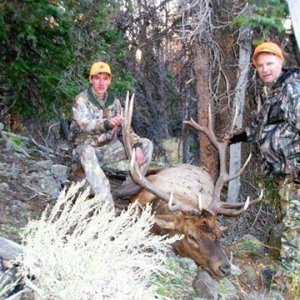
walltenthunter
Member
- Messages
- 9
If one is a fan of aerial maps in hunting (I am pull up Google then click on 'More' then 'maps'. Enter your nearest town then move where you can then navigate directional as needed using identifiable landmarks like rivers, mountains, lakes, riparian wetlands, landscape, etc.
Using this method one can have 3 dimensional perspectives on hunting areas using (a) BLM/National forest service maps, (b) topos from USGS, then gravitating to the aerials, which I like the absolute best. One can readily see timber density, change of vegetation, openings, lakes, and rivers. When I used to hunt new areas, I always used aerial maps to suggest places I thought would pan out. Not all do, yet doing as much homework ahead of the hunt is not only fun, but productive.
This fall the old aerials I had for the area I hunt alot were incomplete (used to get from USGS taking weeks to procure) so I pulled up four adjacent color aerials on Google, then cut and laminated in clear plastic at Kinkos. Total cost involved was less than $2.00. I you want something to compare the aerials too, laminate back to back sides of one side a topo or ntl forest boundaries, and the other side the aerials.
Then you have no excuse for getting lost.
P.S. Use a marking pen to mark private property boundaries using the topos. Then you have a map virtually no else has,
because one has to know where you are in the world of hunting. Cut to size (mine is 8" x 14")you can carry it in your back pack.
") ~
~