Getting kicked off public land

Oneye

Active Member
Messages
443
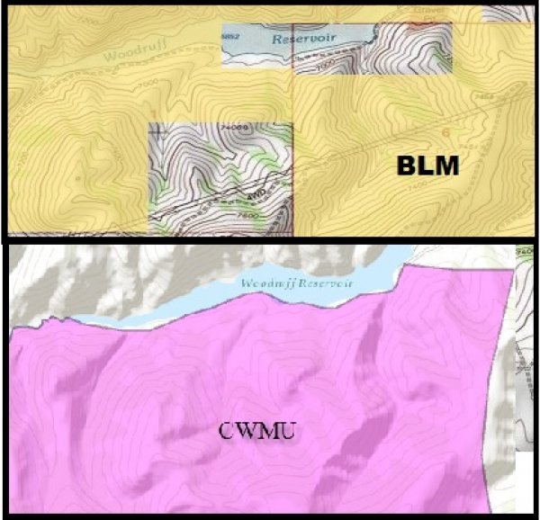
Watched this video today, amazing the crap some people try to pull. OnX maps is a great tool to have for sure, I've got the phone version and the GPS, it's worth it for sure. Just another example of a future of what hunting will be like if states get their way and start selling section by section of our amazing federal lands off. How many have had an issue like this?

https://youtu.be/o_jl3AbBNPg


Protect our public lands: http://www.backcountryhunters.org

And also know where you're at on them and use them: https://www.onxmaps.com
 
I also use OnXmaps, but you still need to be careful because it's not guaranteed accurate.


avatar-1.png
 
I once hunted a tract of State Land in Summit County that was adjacent to private land, which was part of a CWMU. Maps clearly showed where the private/state land boundary was in one of the small canyons. Map of the CWMU showed that it ended in the same canyon. The year I hunted there, there were a few people on horses meandering around. There were no shots anytime I was there. I saw only one spike deer.

My cousin (who was a 17yr old kid) was there in the middle of the week with a friend. When they came down off the mountain in the middle of the day to go to work that night, a guy met them at their truck and told them they were not welcome there. He told them they had been trespassing and he would call the sheriff if he saw them there again. My cousin said his family and others had been hunting there before, and maps showed it was state land. The guy said, "it's all private, don't come back."

As I look at the most recent map of that area, it still shows in blue... And the CWMU border is still in the same small canyon...

"Therefore, wo be unto him that is at ease in Zion!" 2 Ne. 28: 24
 
I had a land owner go out of his way to walk over to me and tell me I was on his private property, I said that I wasn't and showed him the GPS with the line, he changed his tune and said, "Yeah, but over there is private." This "ranch" used to post a lot of state property every year when they clearly didn't own it, apparently inviting the county sheriff to hunt your land for free had it's perks.

Rut
 
I have found most ranchers and farmers are very forgiving and let you through (especially archery hunters as they seem to take things a little more seriously) but there sure are a few who try to bully anyone who tries to come close to their land.
 
Yep,LOL

"I have found if you go the extra mile it's Never crowded".
>[Font][Font color = "green"]Life member of
>the MM green signature club.[font/]
 
There sure are some POS landowners out there. Good for him not getting intimidated off the public land.
 
>I once hunted a tract of
>State Land in Summit County
>that was adjacent to private
>land, which was part of
>a CWMU. Maps clearly showed
>where the private/state land boundary
>was in one of the
>small canyons. Map of the
>CWMU showed that it ended
>in the same canyon. The
>year I hunted there, there
>were a few people on
>horses meandering around. There were
>no shots anytime I was
>there. I saw only one
>spike deer.
>
>My cousin (who was a 17yr
>old kid) was there in
>the middle of the week
>with a friend. When they
>came down off the mountain
>in the middle of the
>day to go to work
>that night, a guy met
>them at their truck and
>told them they were not
>welcome there. He told them
>they had been trespassing and
>he would call the sheriff
>if he saw them there
>again. My cousin said his
>family and others had been
>hunting there before, and maps
>showed it was state land.
>The guy said, "it's all
>private, don't come back."
>
>As I look at the most
>recent map of that area,
>it still shows in blue...
>And the CWMU border is
>still in the same small
>canyon...
>
>"Therefore, wo be unto him that
>is at ease in Zion!"
>2 Ne. 28: 24


I think I know of the same spot you're talking about. I have heard similar stories. Been there myself a time or two but never saw another soul.

4abc76ff29b26fc1.jpg
 
Actually...There is a really strange law in the CWMU rule that allows landowners to take away public land to "make a more enforceable boundary". I have had a few experiences with this is years past, and it wasn't until I started really digging into the CWMU rules that I fully understood what was going on.

CWMUs can actually trade tracts of land over to the state in order to secure better lands that may serve as a better boundary for the private land. These transactions are never updated on any mapping system and never will be. The land is still public land, but cannot be accessed to hunt anything specified on the CWMU sign. So you can still go in there, you can't hunt deer or elk or whatever the CWMU is allowed to hunt.

While on the CWMU advisory committee, I pushed to have this rule taken out as it causes confusion. However, I was outvoted by the several guides, landowners, and ranchers that make up the committee.

The question I pose today is: "Can we take away private land to make a better/more enforceable public land boundary?" The answer is always "NO". But taking away the public land seems to be no problem. I have always had a huge issue with this rule.

HJB
 
HJB,

Curious...in that scenario, if a guy were to stick to his guns and hunt the public land (believing he was in the right for provably being on public land), what enforceable consequence could be imposed on him? And how likely could he fight it and win?
 
Someone said archery hunters "take things more seriously" or some such drivel. One of the stupidest comments I've read here lately. mtmuley
 
>Someone said archery hunters "take things
>more seriously" or some such
>drivel. One of the stupidest
>comments I've read here lately.
>mtmuley

Mtnmuley,

Obviously I was not saying every bow hunter takes it more seriously than every rifle hunter. That is idiotic. I know some bow hunters who are very poor ethically towards the sport and some rifle hunters who are the salt of the earth and would do anything for the sport. Would you guess that there are more poachers with rifles? As far as rifle hunting goes, which I am a rifle hunter myself when I draw a tag, there is a lesser level of work to hunt (coming from a non mountainous region) that will attract the type of person who will kill for backstraps and leave the rest. I don't think this is deniable. Again, zero percent beef against a rifle hunter but I do believe there are more "bad" rifle hunters than there are "bad" bow hunters.
 
Over the years I've had incidents like that and clearly tell that they are lying and if they want to do something about it
lets get it settled right now....surprising they always back down....you can't bullshit an old bullshitter...
 
There's not many things I enjoy more than putting a bully landowner in his place when they accuse me of trespassing on public land when i can illustrate that you know exactly where you are with a GPS and good map reading skills.
 
>HJB,
>
>Curious...in that scenario, if a guy
>were to stick to his
>guns and hunt the public
>land (believing he was in
>the right for provably being
>on public land), what enforceable
>consequence could be imposed on
>him? And how likely
>could he fight it and
>win?

No idea. The maps show the land status, but the CWMU rules say otherwise. I'm sure you would probably get screwed over if you stuck to your guns. I wouldn't recommend it.
 
Would that particular question fall under the UDWR and SITLA agreement? DWR pays SITLA a specific amount of money to keep the "state land" open for hunting. Technically the "state land" is not open to the general public w/o that agreement. The DWR could legally fold the leased "state land" into a CWMU agreement to keep boundaries how they wish. Therefore, a person would be trespassing. But I don't really know.
 
I believe onxmaps shows cwmu boundaries too. I will have to pull the garmin out tomorrow and check. I know it shows private land boundaries labeled for walk in access areas for sure though...
 
That's just weird that CWMU's have a hunting buffer zone beyond private land. Especially since it won't show up on maps.
 
Here's an example of what I'm talking about. If you look at ONXMAPS or a BLM map, or any land status map online, you will identify this piece below as BLM land open to public use. However, when you look at the map on the DWRs website, the land is marked as CWMU. The only way someone would know this is if they looked at the DWR map online. The land is also fenced off and marked as a CWMU with signs. This causes a TON of confusion to anyone looking to hunt this BLM land. (I have personal experience with this piece).

The CWMU is legally authorized to take possession of the land for hunting rights with the approval from the DWR. As long as they provide trade lands in return or additional public tags, they can take the land and use it in the CWMU. The public has no say in this decision whatsoever.

In this case, the trade lands are sage flats with sage grouse and rabbits. While the BLM has a bunch of good deer hunting. In my personal opinion, this was a terrible trade.

48133wccwmu.jpg
 
LAST EDITED ON Oct-31-16 AT 03:24PM (MST)[p]http://www.monstermuleys.info/photos/user_photos_2016/3121420161031150823.jpg

Here is the mobile app version of onxmaps shwing the same spot. The hard black line outlines the cwmu boundary with the dotted section showing included lands. This will hold true with included public. Also, on public in the middle of a cwmu that is not included in cwmu it has a hard blackline around the excluded section and no dots. So, onxmaps probably gives you the best maps to rely on in the field.

I am still gonna check my chipped maps in my gps as well tonight to make sure it shows the same too.
 
Thanks for the information. I learned something today. I guess a person needs to check the regulations and the online DWR maps when considering a place to hunt.
 
The safest way to play it is to use the kml file you can download for free for each CWMU from the DWR website. It gets updated when lands change hands, and shows which public land, if any, are included in the CWMU boundaries.

2a0fcsk.gif
 

Click-a-Pic ... Details & Bigger Photos
Back
Top Bottom