Well actually, there is a guy who made a training CD and showed how to add GPS, topos, and a whole bunch of stuff to Explorer. He had links to the different web sites and such also. A very nice site to say the least.
My brother is computer illiterate and so I created that ArcGis video to show him and a cpl other friends how to install and add the topos in a step by step fashion. Trying not to delve into the areas where the other guy had gone, since I had purchased one of his CD's.
The other guy got pissed and posted on his site that I "massaged" his data and "while not illegal, negated 3 years of work" so he was no longer selling cd's and was closing the web site.
He conveniently left out the fact that the developers of ArcGis have a 1 hour training video on their site, free of charge. He also didn't mention the only thing in common was the GPS and topo maps.
It's unfortunate, I had no intentions of taking sales away and have at every opportunity, steered people to his web site.
I have another video that goes into detail showing how to add the game dept data, shape files from the FS showing water, trails, land ownership. How to add FS maps for some FS districts. Where to go for the different Game dept info and stuff like that. It's made for the computer challenged also. Shows how to extract the zip files and all that stuff that confuses new people.
I haven't posted it up because I didn't want to step on his toes.
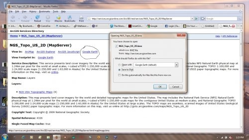
For the ESRI tutorial you can go here:
You will need to create a login to see the ESRI tutorial but it's no big deal.
http://training.esri.com/acb2000/showdetl.cfm?DID=6&Product_ID=961")