which maps do you scouting for a hunt.

R

red

Guest
I am wondering what kind of maps you use for looking over a unit, to find some spots to scout and or put a trail camera? I am also wonder where you find out about private property boundaries or even city limit boundaries.
 
red, I really like the micro SD card map from huntinggpsmaps.com. The card is $99 and goes into the micro SD slot on your GPS (providing it has one). It is really nice to know for sure that you aren't wandering around on someone's private property. I've hunted with BLM maps before that show public/private property boundaries, but the GPS option is way more accurate, and it is very nice knowing exactly where you are in relation to private/tribal lands, which was sometimes confusing when using a regular map. The cards also have a decent topo map overlay on them that gives you a good idea for terrain contours as well.

Just for scouting purposes, I really like the wilderness.net website. If you go to the maps portion of the website, you can look at aerial and topo maps and flip back and forth between the two, and I really like this option. You can't print the topos directly from wilderness.net, but you can get a good feel for an area with this website.

Good luck!
 
Once you find some spots on maps, spend some time on google earth. You can see well used game trails, unmarked water, saddles, etc. You can find good places to hang your cameras. Good luck.
 
Hey muley505 have you ever used the huntinggpsmaps.com mobile app. for android or Iphone? I would rather go to the app. store and pay $29.99 a year. Than pay $99.99 for an SD card and have to buy a new Garmin GPS unit to use the SD card. I am looking into the mobile app. If it is just as good? What do you or anyone else think about this?
 
I have not used the app option, but a friend of mine has, and I think it essentially has the same data. The only problem is that it only works where you have cell reception because a cell signal is needed so the maps can load. If you know the area you are planning on hunting has a good cell signal, I would save a little money and go with the app, but if it doesn't, I would definitely go with the SD card option as your GPS should have a signal everywhere. Hope that helps.
 
Yes, but the phone isn't able to indicate your position on the map without a cell signal (at least my phone doesn't). The major benefit to getting the GPS version is that it shows your location, in real time, in relation to the boundary of whatever private property you are trying to avoid, and it does this in areas where cell reception is not available. I like knowing for sure, not just guessing, that I am not on private property, and this is where the GPS version is better in my opinion.
 
LAST EDITED ON May-28-14 AT 01:05PM (MST)[p]

Muley, your phone is messed up, or the GPS is turned off. Todays phones use cell towers to triangulate a position but also have a stand alone gps chip.
 
Wapiti, that's interesting. I'll have to fiddle with my phone a little. I have the GPS function on, but I have never been able to have my position triangulated on any of my mapping apps when I was outside of a cell service area. Shoot, I can't hardly even get the apps to load when I'm outside of cell service.

Just as an example, I hunted barbary with a friend this year in the southeast corner of NM. I have a GPS tracking app on my phone so my wife can at least know where to start searching for my body, and there was about a fifty-mile area in the far southeast corner of NM that had absolutely no tracking data on my movements, and only once I got into cell tower range did that app start tracking my movements. It may have just been that the app doesn't consistently use the GPS option or something and the huntinggps maps app does, but I definitely wouldn't have bet my life or my next 3 years of hunting privileges on it. Even if the GPS function on my phone does work, I still am going to primarily fall back on my hand-held GPS just because I trust it more. I would be curious to know if others are able to use the huntinggps maps app when they are definitely out of cell service or not? It would be awesome if you could, because it would save people $60, but I still have my doubts.
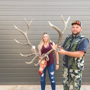
Thanks.
 
You can use the huntinggpsmaps.com chip in your computer. You just have to download Garmin basecamp program. It works great.
 
Just an update on this thread about the app functioning when outside of cell service range: I attempted to use the app in an area where I don't have a signal, and the app itself would not even open on my phone, so, again, I don't think this is a reliable way to know your position as far as private/public land boundaries are concerned. The GPS and chip are the way to go in my opinion if you are going to be hunting in an area where there is no signal.
 
There are thousands of people using backcountry navigator and onXmaps on their phones without cell service. They download the maps when they have cell service then use the phone as their gps when in the mountains.
 
If you have an Android device I highly recommend the "Back Country Navigator" app.
I think the app is $10.
The public and private land boundaries for Utah, Colorado, and Wyoming are like $10-12 each.
You can also download the hunt area boundary maps in some states, I have WY.

You only pay once and the app and add-ons are on your Google account. (Can be downloaded onto new phones without being charged again)

Before you leave to go scouting or hunting you download the map of the area you are going to be in and you will have the map with you when you are out of service.
I put my phone in air plane mode and my GPS/Maps work great.
My phone is the Moto-X.
I like the USA Topo Maps-ArcGIS map source best.
I have used the hunt maps GPS chip as well but it is not as good as Back Country Navigator. IMO.
 
LAST EDITED ON Jun-09-14 AT 07:55AM (MST)[p]Rambo, after looking at the Backcountry app, it looks like I stand corrected. Thanks for the helpful feedback. The Backcountry Navigator App looks very useful, and I look forward to giving it a try.
 
I recommend Spyglass. It's great for navigation: you can mark waypoints, save locations to get back to them later. It allows to read maps with only GPS signal and shows your gps coordinates, altitude and more. It also has a rangefinder and 5xzoom.
 

Click-a-Pic ... Details & Bigger Photos
Back
Top Bottom