Google Earth Unit Overlays

toprut

Member
Messages
16
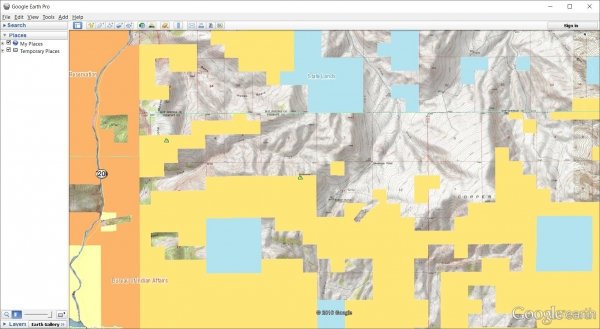
For those of you that love to scout and explore Google Earth, I thought I'd share our library of free kml unit maps. We cover 11 western states and include unit boundaries, USGS topo quads, land ownership and more. Hope someone finds them useful.

Google Earth Unit Maps
 
I tried using the app but it red flagged me telling me my email address was invalid.....its an email i use all day every day.
Help?


avatar-1.png
 
Trying to get a general elk boundary line for the fish lake, will this be available eventually? Thanks!
 
Very cool. I bet this took you guys a lot of time to put together. I just downloaded my utah antelope unit. So far I am really liking what I am seeing. I have built my own mapping for different hunts over the years, but having it all together in one easy download is extremely helpful.

I like how there are separate layers to turn on/off the different contours for each quad. The roads layer is nice, alot more info than what is provided by GE.

What I don't like so far is that the when all layers are on the landownership layers get sent behind the contour layers. I have not played around with this much yet so there may be a way around it.

Overall I am really liking what you have done. This is going to be a great tool to use in scouting and planning new areas.
 
I believe the Limited Entry boundary for Fishlake is the same boundary for the General Spike hunt? In that case the Fishlake file is available under Limited Entry elk.

And just as an fyi, right now the Forest Service Motor Vehicle Use map for Fishlake is not included in the download. I had trouble getting that GIS download from the Forest Service but a nice gentleman with USFS sent me what I needed yesterday. It will be available in the next couple of days once I get time to get it loaded.
 
Yeah I wish there was an easy fix for that. Google Earth doesn't allow you to put a native polygon (the land boundaries) on top of an image overlay (the topo contours). The work around is to adjust the transparency of the topo contour layer so you can see through it to the boundaries underneath. see Adjusting Transparency
 
I submitted several requests on your website, but never received anything in my email inbox - any ideas what I may have done wrong?

Love your site so far and the things you guys are offering to everyone! Good stuff!
 
Ive got an interesting question that I feel this may be the right thread to ask.

I hunt a portion of the fishlake that borders a CWMU. I always hunted one corner of public land that had a fence torn up and not in working order but both sides of this fence were public ground. A few years back a new fence was installed but posted with CWMU signs. The particular plot of land still shows as being USFS land on both sides of the fence but is posted as CWMU. I feel they may have just taken the path of least resistance and used the old fence line instead of supplying a new one. If it shows public USFS land, can it be hunted on a General season unit?
 
Maxxy take a ride/show them on a map with a USFS Ranger and get that information straight up from them. If it a illegal fence they will be more then happy to have it removed.

"I have found if you go the extra mile it's Never crowded".
>[Font][Font color = "green"]Life member of
>the MM green signature club.[font/]
 
Gator, I think that would be the best solution. In the meantime in your opinion am i safe to hunt both sides. This particular parcel that is now fenced is an absolute huge part of the Elk's daily routine for the herd I hunt. Its basically the difference between having multiple chances at my General Season Spike, or trying to find a needle in the Haystack (which is fun too). This just affects my hunting more than a similar situation in another portion of the unit.

Anyway, just thinking aloud.

Thanks!
 
toprut,
I LOVE your site and I am sorry if I hijacked your thread, just thought they went hand in hand. apologies.
 
I downloaded a map, all I am seeing is a blue line that shows the hunt boundary. Is there more to this that I'm not seeing?

O--one
B--big
A--ass
M--mistake
A--america
 
>I downloaded a map, all I
>am seeing is a blue
>line that shows the hunt
>boundary. Is there more to
>this that I'm not seeing?
>
>
>O--one
>B--big
>A--ass
>M--mistake
>A--america
>
>
>
>
>
>
>
Go up in the left top corner and put a check in the box options that you want to see.

avatar-1.png
 
LAST EDITED ON Jul-10-16 AT 06:38PM (MST)[p]

>
>What I don't like so far
>is that the when all
>layers are on the landownership
>layers get sent behind the
>contour layers. I have not
>played around with this much
>yet so there may be
>a way around it.
>
>Overall I am really liking what
>you have done. This is
>going to be a great
>tool to use in scouting
>and planning new areas.


Earthpoint topo server from earthpoint and SMA overlay server from geocommunicator.

The downside is they require a live internet. The ops maps will work in GE without internet; ie your laptop back in camp.


5437clipboard01.jpg
 
LAST EDITED ON Jul-10-16 AT 06:58PM (MST)[p]nothing but red X's

O--one
B--big
A--ass
M--mistake
A--america
 
>
>Earthpoint topo server from earthpoint and
>SMA overlay server from geocommunicator.
>
>
>The downside is they require a
>live internet. The ops maps
>will work in GE without
>internet; ie your laptop back
>in camp.
>
>
>
5437clipboard01.jpg


Earthpoint is one of the servers I use when I am creating my own maps. I have several different servers I use depending on what I am trying to do.
 
Top rut I am not getting land ownership layer . Is it not available for all units?

Bill

People who work for a living are quickly being
overwhelmed by people who vote for a living.
 
We've found one scenario to duplicate this problem.

If you choose to Open the file (and not save it) from the browser, the KMZ file will get deleted once you close the browser window. Then you will run into the red X issue when turning on topo roads or contours.

Always choose the Save or Save As option if prompted during download.
 
Toprut, i am on the ut-chalk creek/east canyon and it does not show private property. there is no box to check for private property either. Can you help me out with this please?
 

Similar threads


Click-a-Pic ... Details & Bigger Photos
Back
Top Bottom