Maps!!!!

I'll second that for mytopo.com great maps and fast build your own based on where you want to hunt-Hatrick
 
LAST EDITED ON Jul-15-09 AT 12:17PM (MST)[p]Not sure if you are looking for printed maps or just something to display on a PC. If you want online maps, here are a few:

MyTOPO is a good system as others already mentioned.

IDFG's hunt planner system has a lot of good features, I especially like seeing the private/public land ownership boundaries:
http://fishandgame.idaho.gov/ifwis/huntplanner/mapcenter.aspx

I just discovered this GIS system from the BLM last week. It has some features the F&G system doesn't, and vice versa. Hint: uncheck the "PLSS" checkbox to remove the township grid overlay.
http://www.geocommunicator.gov/LSIS6/map.jsp

An updated travel map from the land-management agency for the area should also show all the road data you may need.

My personal preference is Google Earth, except it doesn't have any creek or river names in it, so that makes navigation tough. However, last week I stumbled across a link where you can download a .kmz file to overlay USGS topo maps into Google Earth. Problem solved! Link to .kmz file is in this blog entry:
http://www.gearthblog.com/blog/archives/2006/03/best_topo_map_i.html
 

Click-a-Pic ... Details & Bigger Photos

Idaho Hunting Guides & Outfitters

Bearpaw Outfitters

Idaho Deer & Elk Allocation Tags, Plus Bear, Bison, Lion, Moose, Turkey and Montana Prairie Dogs.

Urge 2 Hunt

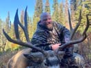
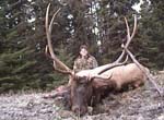
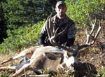
We focus on trophy elk, mule deer, whitetail, bear, lion and wolf hunts and spend hundreds of hours scouting.

Jokers Wild Outdoors

Trophy elk, whitetail, mule deer, antelope, bear and moose hunts. 35k acres of private land.

Back
Top Bottom